Version History
Here you can find the changelog of Wavve Boating: Marine Boat GPS since it was posted on our website on 2019-06-12.
The latest version is 4.7.4 and it was updated on soft112.com on 22 April, 2024.
See below the changes in each version:
version 4.7.4
posted on 2024-04-12
We’ve made further improvements to the routing and mapping experience. We’re always eager for your feedback. If you ever need a hand, please reach out at community@wavveboating.com.
version 4.7.3
posted on 2024-03-27
In this update you'll find further improvements to auto-routing! With two taps, pick any two locations and let Wavve Boating calculate a route for your consideration. If you ever need a hand, please reach out at community@wavveboating.com.
version 4.6.6
posted on 2024-02-12
In this update you find new and improved map symbols in addition to a re-designed menu. Adjusting your boat draft, changing units, and setting the map style to your preference is now easier than ever. If you ever need a hand, please reach out at community@wavveboating.com.
version 4.6.5
posted on 2024-01-25
In this version you will find further improvements to the map depth contours. Have you tried the new and improved auto-routing? HOP TO IT! Haha – Update today and have fun out there
version 4.6.4
posted on 2024-01-22
Some great improvements thanks to the Wavver community! The transition from north up to bearing up while at speed is smoother, improved button interaction, and further improvements to the tide station selector. Have you tried the new and improved auto-routing? WHAT ARE YOU WAITING FOR! Haha – Update today and have fun out there
version 4.6.2
posted on 2024-01-09
Massive improvements to Auto-Routing! Also, we've enhanced the offline functionality of the Wavve app to SeaDoo integration. Reach out anytime at community@wavveboating.com and let us know what you think.
version 4.6.0
posted on 2023-12-22
Massive improvements to Auto-Routing! We're excited to get this in your hands for some Holiday Boating. Reach out anytime at community@wavveboating.com and let us know what you think.
version 4.5.9
posted on 2023-12-22
You asked for it, so we built it, you can now set the Wavve Boating map permanently to a north up heading. Within this release you will also find improvements to the map experience.
Questions? Reach out at community@wavveboating.com.
version 4.5.2
posted on 2023-11-01
You can now share locations and routes outside of Wavve Boating to friends so they can easily access your content on their own Wavve Boating account. Save time planning, or communicating that perfect anchorage, and leverage your boat bud’s knowledge. Find this feature by tapping the share button on applicable content. Questions? Reach out at community@wavveboating.com.
version 4.4.7
posted on 2023-08-24
We’ve added more information to the depth contour lines! This was another great recommendation from our customers. We are constantly listening to you (the boater), developing improvements, and getting them in your hands. Contact us anytime at community@wavveboating.com.
version 4.4.5
posted on 2023-08-18
We’ve made some great improvements to the auto-routing calculation speed! We are constantly listening to you (the boater), developing improvements, and getting them in your hands. Contact us anytime at community@wavveboating.com
version 4.4.1
posted on 2023-07-26
You can find improvements to the addition of Wavve points and the community tab in this release.
We are constantly listening to you (the boater), developing improvements, and getting them in your hands.
Contact us anytime at community@wavveboating.com
version 4.3.8
posted on 2023-07-10
Bahamas and UK nautical charts! Woooohooo
O ya, a number of other improvements thanks to feedback from our awesome community.
Contact us anytime at community@wavveboating.com
version 4.3.7
posted on 2023-06-23
More improvements and tweaks! Have you checked out our new dark mode or tides feature? If not, now is the time to do so.
We would love to know what you think, contact our team anytime at community@wavveboating.com.
version 4.3.1
posted on 2023-05-26
Dark mode map! In addition to the default map and satellite view, you can now view the map in dark mode!
More updates and improvements are always coming your way.
We would love to know what you think, contact our team anytime at community@wavveboating.com.
version 4.2.4
posted on 2023-05-10
A ton of feature experience improvements + offline saving is completely automatic. Check out this release, we think you'll love it!
As always, please reach out anytime at community@wavveboating.com
version 4.1.2
posted on 2023-04-04
Further improvements to auto-routing! You will find it even faster at calculating the best route between two locations on the water considering the draft of your boat, the water level conditions, and nautical channels.
As always, please let us know what you think at community@wavveboating.com
version 3.6.5
posted on 2022-05-17
Check our the new Wavve Feed! See popular boating destinations and compete to be the #1 boater in your area!
As always, we'd love to hear your thoughts - community@wavveboating.com.
version 3.6.4
posted on 2022-05-11
We are very excited about this release! Get ready for the Wavve Feed! See popular boating destinations and compete to be the #1 boater in your area!
As always, we'd love to hear your thoughts - community@wavveboating.com.
version 3.5.9
posted on 2022-04-11
More improvements for those who use Wavve Boating through their integrated display on their 2021/2022 SeaDoo - lucky bunch.
As always, we'd love to hear your thoughts - community@wavveboating.com.
version 3.4.4
posted on 2022-02-25
You can now zip through the Wavve Boating onboarding without creating an account. Navigate confidently faster and create an account later when it is convenient for you!
As always, we'd love to hear your thoughts - community@wavveboating.com.
version 3.4.2
posted on 2022-02-03
We've updated the main map layout to make everything a bit easier to access!
As always, we'd love to hear your thoughts - community@wavveboating.com.
version 3.3.3
posted on 2021-12-23
More under the hood improvements. Who doesn't love a quick and smooth app experience!
Let us know what you think at community@wavveboating.com.
version 3.3.2
posted on 2021-11-16
We've added banner bars that will show up when a Club or friend shares content with you! This bar will allow quick access to this point of interest, route or announcement.
Let us know what you think at community@wavveboating.com.
version 3.3.1
posted on 2021-11-04
Share routes, trips and points of interest with your friends using your Wavve Boating Fleet! Save time coordinating and communicating with your boat buds on where you are going, and how you will get there.
+ More product improvements.
Let us know what you think at community@wavveboating.com.
version 3.2.2
posted on 2021-10-01
Share routes, trips and points of interest with your friends using your Wavve Boating Fleet! Save time coordinating and communicating with your boat buds on where you are going, and how you will get there. We're very excited about this release and we hope you are too!
Let us know what you think at community@wavveboating.com.
version 3.2.1
posted on 2021-08-27
A whole new way to share exclusive information with your boating community!
This version of Wavve Boating is Wavve Clubs capable - meaning you can join a Club, or create your own, using our web portal to share points of interest, routes, send messages and manage access. Visit wavveboating.com/partners to learn more.
version 3.1.8
posted on 2021-07-21
As per Wavver request, we've added banner warnings (+audio) when you proceed into shallower bodies of water. We hope this will provide you with more peace of mind when on the water this weekend!
Let us know what you think!
version 3.1.4
posted on 2021-06-28
A lot of new features over the past month including, an automatic tidal map, weather alerts based on coast guard warnings, an improved design, enhanced help/feedback, and more. This update includes further refinement and improvement to make your time on the water that much more fun and relaxing.
Let us know what you think!
version 3.1.0
posted on 2021-06-17
A lot of new features over the past month including, an automatic tidal map, weather alerts based on coast guard warnings, an improved design, enhanced help and feedback, and more. This update includes further refinement and improvement to make your time on the water that much more fun and relaxing.
Let us know what you think!
version 3.0.9
posted on 2021-06-11
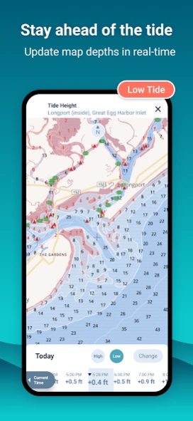
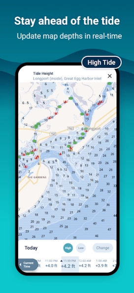
More improvements to make your time on the water that much easier and enjoyable. Check out the latest tidal/water level feature that will update your map to the real-time water depths. Forget worrying about tide tables and focus on what is important to you!
Let us know what you think at community@wavveboating.com.
version 3.0.5
posted on 2021-05-14
The next evolution of Wavve Boating is here! We have completely redesigned the app, with the help of boaters across North America, to provide the best boating app experience. We cannot wait for you to join the new Wavve.
We just expanded the help and settings menu. Within you can change your map to report in feet, meters - speed in kph, mph, knts and much more. Find a bunch of great resources in the new help menu.
Let us know what you think at community@wavveboating.com.
version 3.0.4
posted on 2021-05-05
The next evolution of Wavve Boating is here! We have completely redesigned the app, with the help of boaters across North America, to provide the best boating app experience. We cannot wait for you to join the new Wavve.
We've added a few improvements over the week to get you ready for this weekend of boating!
Let us know what you think at community@wavveboating.com.
version 3.0.2
posted on 2021-05-03
The next evolution of Wavve Boating is here! We have completely redesigned the app, with the help of boaters across North America, to provide the best boating app experience. We cannot wait for you to join the new Wavve.
Let us know what you think at community@wavveboating.com.
version 2.9.3
posted on 2021-04-19
Improvements for those using Wavve Boating on their 2021 Sea-Doo GTX.
Let us know what you think at community@wavveboating.com
version 2.9.3
posted on 2021-01-27
Lots of little improvements to make your experience on the water better!
Let us know what you think at community@wavveboating.com
version 2.9.1
posted on 2020-12-17
Mark all your favorite spots remotely! Want to mark that great beach spot from last weekend? Now you can from the comfort of your home, save it privately, or make it public for other Wavvers!
Let us know what you think at community@wavveboating.com
version 2.8.2
posted on 2020-09-10
You can now add photos when marking all your favorite spots on the water with Wavve Boating! See what other Wavver's are adding, sometimes a picture really is worth a thousand words!
+ Now you can add Wavver's to your fleet directly from the map. Save time building your group of boating friends.
Let us know what you think at community@wavveboating.com
version 2.6
posted on 2020-08-14
You can now add photos when marking all your favorite spots on the water with Wavve Boating! See what other Wavver's are adding, sometimes a picture really is worth a thousand words!
Let us know what you think at community@wavveboating.com
version 2.5.1
posted on 2020-08-06
New category fields to mark all your favorite spots with Wavve Boating. You can now report how many docking slips are available at restaurants, public docking areas and more.
Let us know what you think at community@wavveboating.com
version 2.3.1
posted on 2020-06-25
New categories to mark all your favorite spots with Wavve Boating. Check out what other Wavvers are adding!
Let us know what you think at community@wavveboating.com
version 2.2.1
posted on 2020-06-12
New and improved designs for crowd sourced information! Mark all your favorite spots with Wavve Boating.
+ Easily see where you're heading with a newly added direction line! This will become visible at speed.
Let us know what you think at community@wavveboating.com
version 2.0.2
posted on 2020-05-27
New onboarding screens and subscription options!
Let us know what you think at community@wavveboating.com
version 1.9.9
posted on 2020-04-03
Search marinas, restaurants, boat ramps and more + new direction indicator feature to help you get there!
Let us know what you think at community@wavveboating.com
version 1.8
posted on 2019-10-31
Ahoy Captain! Check out what's new in this version:
- Thanks to awesome feedback from the Wavver community, we have improved the navigational view!
Let us know what you think at community@wavveboating.com
Enjoy!
version 1.7
posted on 2019-09-27
Ahoy Captain! Check out what's new in this version:
- You can now pause and resume any of your trips (recorded breadcrumbs) while on the water. In addition, we did some housekeeping and improved the app appearance.
Let us know what you think at community@wavveboating.com
Enjoy!
version 1.6
posted on 2019-09-12
Ahoy Captain! Check out what's new in this version:
- Big update! You can now share and search for community trips(recorded breadcrumbs) on the water. Looking for a new adventure? See what other Wavver's have shared, or why not create your own so fellow Captains can follow in your wake.
Let us know what you think at community@wavveboating.com
Enjoy!
version 1.5
posted on 2019-08-31
Ahoy Captain! Check out what's new in this version:
- BIG UPDATE - Easily plan your route and record your trips!
Let us know what you think at community@wavveboating.com
version 1.4
posted on 2019-08-10
Ahoy Captain! Check out what's new in this version:
- Notifications have been added to let you know when someone has joined your Fleet.
Let us know what you think at community@wavveboating.com
version 1.3
posted on 2019-07-19
Ahoy Captain! Check out what's new in this version:
- Build your own Fleet! Huge update, Wavvers can now create their own friend groupings to easily locate each other on the water.
Let us know what you think at community@wavveboating.com
version 1.2.1
posted on 2019-07-12
Ahoy Captain! Check out what's new in this version:
- More improvements across the board to provide a smooth map viewing experience. Let us know what you think at community@wavveboating.com
version 1.2
posted on 2019-06-30
Ahoy Captain! Check out what's new in this version:
- Thanks to feedback from the Wavver community, we have made improvements/bug fixes across the Wavve Boating app.
Let us know what you think at community@wavveboating.com
Enjoy!
version 1.0
posted on 2019-05-24
Ahoy Android Captains! We are so excited to release Wavve Boating!
Navigate with confidence - Find your friends - Explore new waters
See you out on the water.